Explore
Featured
Recent
Articles
Topics
Login
Upload
Featured
Recent
Articles
Topics
Login
Upload
Search Results for 'geographic map'
geographic map published presentations and documents on DocSlides.
Analyzing Railroad Accidents Using Geographic Information S
by min-jolicoeur
Subhay. . manandhar. Geographic Information Syst...
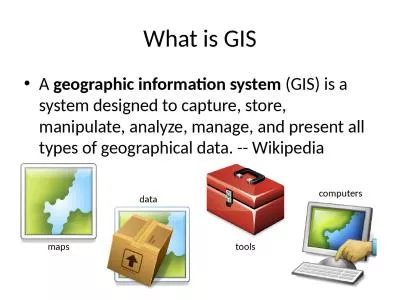
What is GIS A geographic information system
by hadley
(GIS) is a system designed to capture, store, mani...
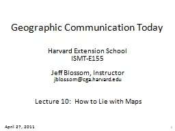
Geographic Communication Today
by pasty-toler
Harvard Extension School. ISMT-E155. Jeff Blossom...
Today:
by karlyn-bohler
Projections and Cartographers. First 10 Minutes: ...
Chapter 1 Key Issue 1 Why is Geography a Science
by lois-ondreau
Big Question. Place. Region. Scale. Space. Connec...
What is a GIS? Geospatial technologies are technolo-gies for collecting and dealing with geographic
by tawny-fly
three main types: . . Global Positioning Systems...
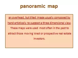
panoramic map
by pamella-moone
an . overhead, but tilted image usually composed ...
LT: I can analyze and determine key information about the d
by tatiana-dople
Introduction to Geographic Luck. Entry Task: Why ...
GIScience: The Next 10 Years
by yoshiko-marsland
Michael F. Goodchild. University of California. S...
GIS (Geographic Information Systems)
by ellena-manuel
Applications in marketing. Austin College. April ...
LT: I can analyze and determine key information about the d
by pasty-toler
Introduction to Geographic Luck. Entry Task: Why ...
BELLWORK Please take out your Tree Maps from yesterday. If you have not done so already, answer th
by celsa-spraggs
Guns, Germs and Steel Episode one: Out of Eden. J...
GEO 241: Geographic Information Systems I
by danika-pritchard
Week 3. :. Cartographic Principles: Classificati...
September 14, 2017 Use of Geographic Data in COP Planning: South Sudan Experience
by myesha-ticknor
2017 PEPFAR Data and Systems Applied Learning Sum...
GEO 241: Geographic Information Systems I
by cheryl-pisano
GEO 241: Geographic Information Systems I Week 3 ...
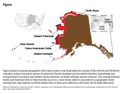
Figure Figure. Composite geographic information system map illustrating the overlap of New
by miller
Winker K, McCracken KG, Gibson DD, Pruett CL, Meie...
Geographic Information Systems (GIS) – climate hazards
by valerie
Getting started. You’ll need a notepad on which ...
Introduction to Cartography
by kittie-lecroy
GEOG 2016 E. Lecture-1. Introduction and Overview...
Introduction to Cartography
by lindy-dunigan
GEOG 2016 E. Lecture-1. Introduction and Overview...
Collecting Geographic Coordinates
by karlyn-bohler
Using GPS Devices. <date of training> ....
Coordinate Systems,
by briana-ranney
Datums. and Map . Projections. D’Arcangelis. 1...
Efficient and effective
by luanne-stotts
result . presentation with GIS. Xiaogang (Marshal...
The Digital Musing of a History Buff
by lindy-dunigan
Charles W. . Kann. Slides available at. : http://...
Physical Geography Day 1
by sherrill-nordquist
We will pose and answer geographic questions abou...
Geographic Information
by pasty-toler
Systems. ASM 215. Feb 2013. Larry Theller. Schedu...
Chapter 1 basic concepts
by tatiana-dople
What is Human Geography?. Key Question:. Human Ge...
Chapter 1 (Rubenstein 11
by kittie-lecroy
Chapter 1 (Rubenstein 11 th ed.) Basic Concepts ...
Chapter 1 basic concepts
by garboardcola
What is Human Geography?. Key Question:. Human Geo...
GIS in Water Resources Midterm Review 2018
by cheryl-pisano
Blooms Taxonomy of Educational Objectives. 2. Com...
Introduction to Geographic Information Systems
by tatyana-admore
Spring 2013 . (INF 385T-28437). . Dr. David Ar...
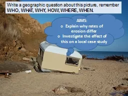
Write a geographic question about this picture, remember
by lois-ondreau
WHO, WHAT, WHY, HOW, WHERE, WHEN. .. AIMS:. E. x...
Introduction to Geographic Information Systems
by lindy-dunigan
Spring 2013 . (INF 385T-28437). . Dr. David Ar...
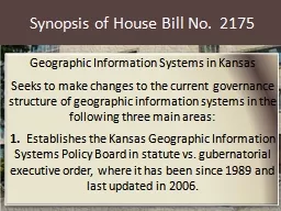
Synopsis of House Bill No.
by calandra-battersby
2175. Geographic Information Systems in Kansas. S...
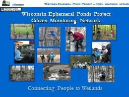
Wisconsin Ephemeral Ponds Project
by lindy-dunigan
Citizen Monitoring Network. W. ISCONSIN. . E. PH...
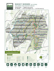
This map is a product of the Geographic Information System o The Trust
by celsa-spraggs
HARTFORD STREETTO MEDFIELD TO WESTWOOD& RT. 95 12...
How to make flash cards out of PowerPoint slides!
by tatyana-admore
See slide 8 for details. 1. Which one of these ca...
Associating Attribute Data In
by pasty-toler
GIS. With support from:. NSF DUE-0903270. Prepare...
Geographic Information Technology Training Alliance (GITTA) presents:
by faustina-dinatale
Generalisation of Map DataResponsible persons: Bor...
This map is a product of the Geographic Information System o The Trustees of Reservations
by liane-varnes
Source data obtained from 125000 scale USGS topom...
COASTLINE CHANGE MEASUREMENT AND GENERATING RISK MAP FOR THE COAST USING GEOGRAPHIC INFORMATION SYSTEM D
by alida-meadow
K Raju K Santosh J Chandrasekar Teh TiongSa Phys...
Load More...